From Category 1 to a forecast Category 4 in barely two days, Simón forced evacuations, closed ports and airports, and put a $175M catastrophe bond on edge.
Published 12 October 2026 · 06:00 GMT
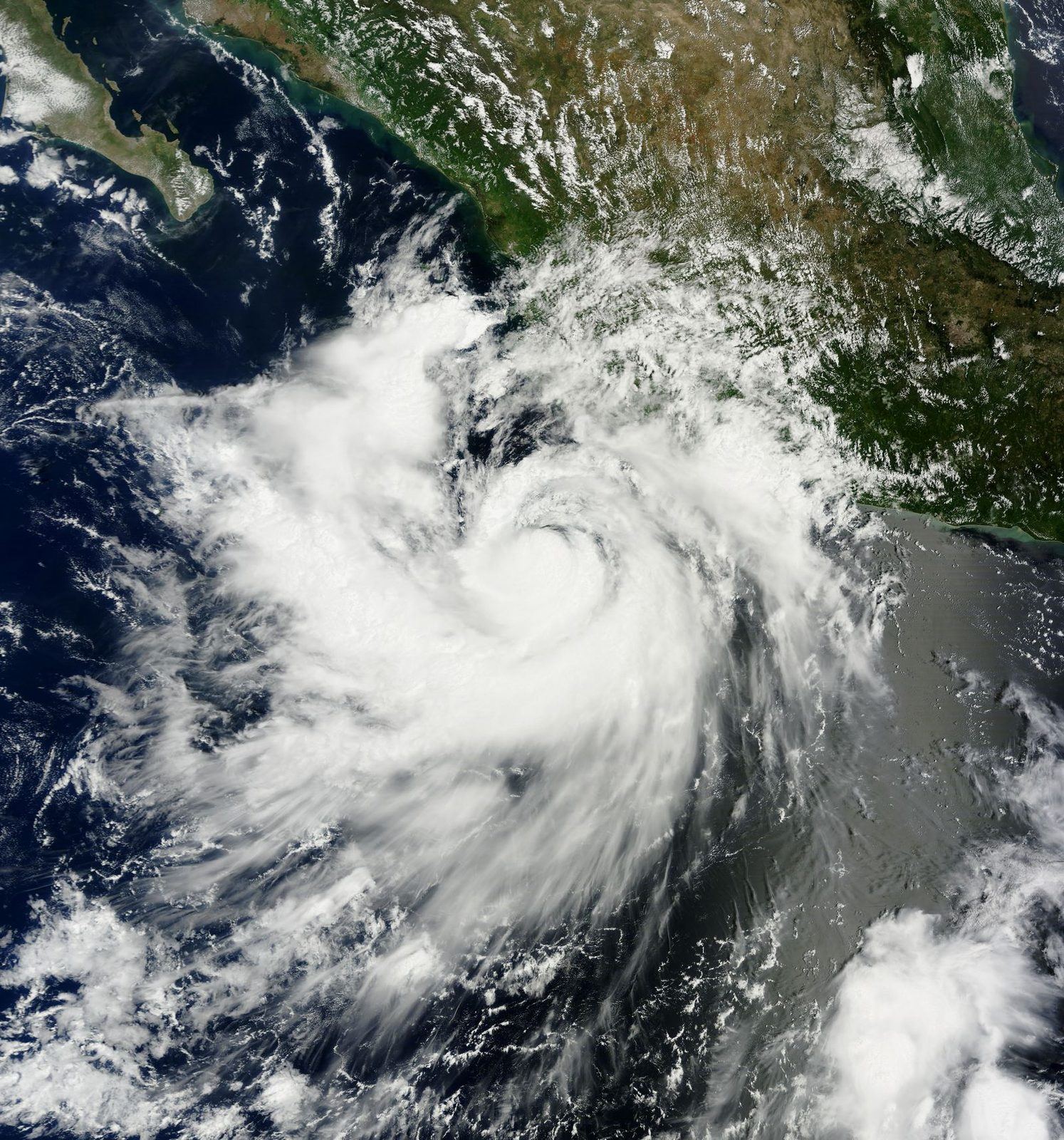
Plywood, spray paint, and a prayer. As Hurricane Simón swelled toward Category 4 off Mexico's Pacific coast, Puerto Vallarta braced the way resort cities do: boarded windows, emptied beaches, suspended flights — and a city's worth of gallows humor facing down the storm as it bore down on the coast.
On a boarded-up shopfront in Puerto Vallarta, someone took a can of spray paint to the plywood and wrote four words: "Simón dice: todo va a estar bien" — Simón says everything will be fine. It was part prayer, part joke, and entirely Mexican: a city of some 300,000 people staring down a Category 4 hurricane with gallows humor and nails. By Sunday evening, the joke had an unlikely ally. The storm, which had spent three days swelling off the Pacific coast, had still not come ashore.
The geography of the fear was precise. At the storm's closest approach, the threatened strip ran from Manzanillo — Mexico's largest port and its main gateway for trade with Asia — to Puerto Vallarta, the resort city of roughly 300,000 residents whose bay fills with tourists even in October. Hurricane warnings covered the coast from Punta San Telmo in Michoacán to Punta Mita in Nayarit, later extended from Punta San Telmo to El Roblito, with a hurricane watch north of El Roblito to Bahía Tempehuaya and alerts for the Islas Marías. It was, in effect, the entire economic spine of Mexico's central Pacific under a single red banner.
“Simón dice: todo va a estar bien” — spray-painted on plywood in Puerto Vallarta, October 2026.
Simón did not arrive as a monster. On Friday, October 9, Reuters reported it as a Category 1 hurricane with winds of 100 mph (155 kph), sitting about 210 miles (335 km) south of Manzanillo and moving northwest — with a forecast that it would reach Category 4 by Saturday. The U.S. National Hurricane Center did not mince words: "Rapid intensification is expected to continue, and Simon is expected to be a very dangerous major hurricane when it approaches the coast of Mexico." Rapid intensification — a jump of at least 35 mph in wind speed in 24 hours — is the phenomenon forecasters fear most, because it can turn a manageable storm into a catastrophe between one advisory and the next.
The short answer is warm water and a cooperative atmosphere. The eastern Pacific in October holds some of the warmest sea-surface temperatures of the year, and Simón found a pocket of low wind shear — the change in wind speed with altitude that can tear a storm's structure apart — that let it organize and deepen almost undisturbed. The longer answer is harder to pin down: snapshots of the storm's peak intensity differed across reports, with estimates ranging from 140 to 150 mph before the National Hurricane Center's October 11 advisory fixed it at 125 mph as a Category 3. Some scientists argue that rapid intensification is becoming more common as oceans warm; that link remains expert opinion rather than settled attribution for any single storm, and it should be read that way.
What no one disputed was the water. The National Hurricane Center forecast isolated rainfall totals of up to 30 inches — 762 millimeters, roughly a year's worth of rain for many cities — across Michoacán, Colima, Jalisco and Nayarit, warning of life-threatening flooding and mudslides. Jorge Zavala, a scientist at Mexico's national university UNAM, told CNN that Friday-to-Sunday totals could reach 300 to 500 millimeters, calling it "un caso extremo de precipitación" — an extreme case of precipitation. In the steep coastal mountains of Jalisco and Colima, that much rain does not drain; it slides, taking roads, hillsides and homes with it.
Mexico's civil protection apparatus moved the way it does when the models agree. The Navy activated emergency personnel in Colima. Ports closed to small craft, and larger vessels were barred from leaving port in Michoacán. In the Jalisco town of El Rebalse, in the municipality of Cihuatlán, 70 people evacuated themselves and 10 more moved into a shelter. Classes were suspended in 22 Jalisco municipalities. Then came the broadest measure: the national civil protection coordination, the CNPC, suspended non-essential mobility starting at 4 p.m. local time on Saturday across 10 municipalities in Jalisco, five in Colima, three in Michoacán and six in Nayarit. Puerto Vallarta's airport suspended arrivals from 5 p.m. on October 10 until 8 a.m. on October 12. The municipal water utility SEAPAL cut service to more than 400 neighborhoods, and a red flag — maximum alert — went up on the beaches on October 10.
The official tone was calm but firm. "We ask people to stay indoors at their homes and in temporary shelters while the hurricane passes," said civil protection chief Laura Velázquez Alzúa on Friday. On the ground, the mood was defiant. Edna Morales, a 41-year-old tourist, told local reporters: "Vamos a disfrutar lo más que se pueda, aunque sea nada más por el día de hoy" — we will enjoy it as much as we can, even if it is only for today. It is the eternal bargain of the resort coast: the same ocean that fills the hotels can empty them in an afternoon.
And then the storm blinked. Advisory 18A from the National Hurricane Center, issued at 6 p.m. Central Time on Saturday, October 11, showed Simón weakened to a Category 3, with winds of 125 mph (205 kph) and a central pressure of 951 millibars. Its center sat about 50 miles south of Cabo Corrientes and roughly 110 miles west-northwest of Manzanillo — close enough to see on the horizon, far enough to spare the coast a direct hit. By Sunday evening, there had been no landfall. A midnight UTC update on October 12, carried by the reinsurance publication Artemis citing the Hurricane Center, showed the storm holding at 125 mph and 951 millibars while tracking parallel to the coast.
That near-miss had a financial shadow. Simón's track put at risk the $175 million IBRD CAR Mexico 2024 (Pacific) parametric catastrophe bond — a financial instrument through which Mexico transfers earthquake and hurricane risk to capital markets. Parametric bonds pay out not on measured damage but on triggers: a storm of a given intensity passing through a defined box. If Simón had come ashore at full strength in the covered zone, investors' money would have flowed to Mexico's recovery; if it stays offshore, they keep their coupons. Artemis analysis suggested the bond would not trigger — but that analysis is not official, and the final word belongs to the calculation agent once the storm's full track is in.
The Pacific corridor has had little rest. Just last week, Hurricane Polo struck Baja California as a Category 2, a reminder that Mexico's 2026 season has been relentless on both coasts. Readers who follow this coastline know it from more than weather: the Bureau has tracked hurricane seasons across the Americas, from Isaias's Florida landfall to this year's Pacific monsters, and the peninsula drew global attention again with the verdict in the Ensenada surfers' murder case. For the deeper country picture — ports, population, exposure — see our Mexico factbook.
The forecast as of Monday morning keeps Simón offshore through today and Tuesday, tracking parallel to the coast, before the storm turns back toward land on Wednesday as a weakening system. That is the central scenario, not a promise: a weakened storm can still drown a mountainside, and the rainfall forecasts for Michoacán, Colima, Jalisco and Nayarit remain the most dangerous part of this event. Warnings and watches stay in force, shelters stay open, and the airports and ports reopen on their own cautious schedules. The spray-painted prayer on the plywood — Simón says everything will be fine — is holding so far. Mexico's civil protection intends to keep it that way.
The Western telling of Simón is a preparedness story. Reuters, CNN and the National Hurricane Center frame it through forecast skill and institutional response: rapid intensification caught early, warnings drawn with precision down to named headlands, a civil protection system — the CNPC, the Navy, municipal utilities — moving in rehearsed sequence. The comparison point is Lidia in 2023, which damaged thousands of homes and devastated crops along the Jalisco coast; the implicit question is whether the machinery built since then holds. AccuWeather's Tyler Roys warned Simón could be the most significant impact on this stretch since Lidia, and Alexander DaSilva spelled out the wind damage — widespread outages, downed trees, structural harm — in the plain language of risk communication.
There is also a markets subplot that Western coverage loves: the catastrophe bond. The $175M IBRD CAR Mexico 2024 (Pacific) instrument turns a hurricane's track into a tradable number, and reinsurance desks watched Simón the way traders watch a jobs report. Artemis's read — likely no trigger — is the kind of unofficial-but-influential analysis that moves before the official calculation agent speaks. The Western lens, in short, sees a storm managed by systems: satellites, models, bonds, bureaucracies.
No distinct Eastern coverage of Simón was found — no Chinese, Russian or other Eastern-bloc wire treatment surfaced in the research for this story. The facts, however, read the same through an Eastern lens, and the emphasis would land in a different place: Manzanillo. Mexico's largest port is the Pacific terminus of a trade corridor that carries Chinese and Asian manufactured goods into the Mexican and North American markets; a direct hit there would have been a supply-chain event, not just a weather event. Through that prism, the storm's offshore track is also a logistics story — containers kept moving, cranes kept standing.
The absence itself is a datum. Eastern outlets that cover Mexico heavily on trade, lithium and diplomacy gave this hurricane little or no play, which says something about where the story sits in their hierarchy of interests: a natural disaster with competent local response and no geopolitical hook does not travel far. The Eastern read, then, is mostly silence — and silence, here, is not disagreement but distance.
The Global South telling of Simón lives at street level. Vallarta Hoy tracked the storm pulling away from the coast; Diario Bahía kept Puerto Vallarta and Bahía de Banderas on alert; CNN Español carried the UNAM science and the municipal drumbeat. This is coverage of shelters and suspended classes, of SEAPAL cutting water to more than 400 colonias, of the airport's arrivals board going dark from Friday evening to Monday morning. The heroes are unglamorous: civil protection chief Laura Velázquez Alzúa asking people to stay indoors, Navy personnel in Colima, the shelter workers in Cihuatlán who took in ten neighbors.
And then there is the graffiti. “Simón dice: todo va a estar bien” — spray-painted on plywood in Puerto Vallarta — and the tourist Edna Morales, 41, insisting she would enjoy the day anyway: “Vamos a disfrutar lo más que se pueda, aunque sea nada más por el día de hoy.” The Southern lens does not treat these as color; they are the story. A coastline that lives off visitors cannot afford panic, so it performs calm — and sometimes, as this weekend showed, the performance holds.
As of Monday morning, October 12, no landfall has occurred and none is forecast imminently. The National Hurricane Center expects Simón to track parallel to the coast, offshore, through Monday and Tuesday, then turn back toward land on Wednesday as a weakening storm. That is the central scenario, not a guarantee — weakened systems can still cause deadly flooding and mudslides, and warnings remain in force for Michoacán, Colima, Jalisco and Nayarit.
The October 11, 6 p.m. CST advisory (18A) rated Simón a Category 3 hurricane with sustained winds of 125 mph (205 kph) and a central pressure of 951 millibars, centered about 50 miles south of Cabo Corrientes. It had been forecast to reach Category 4 by Saturday, and peak-intensity snapshots ranged from 140 to 150 mph — but those figures were never confirmed by an official advisory.
Hurricane warnings covered the coast from Punta San Telmo in Michoacán to Punta Mita in Nayarit, later extended from Punta San Telmo to El Roblito, with a hurricane watch from north of El Roblito to Bahía Tempehuaya and alerts for the Islas Marías. Authorities suspended non-essential movement in 24 municipalities across Jalisco, Colima, Michoacán and Nayarit, closed ports to small craft, suspended classes in 22 Jalisco municipalities, and halted arrivals at Puerto Vallarta's airport.
Manzanillo is Mexico's largest port and its main gateway for trade with Asia, so a direct hit would disrupt container flows into Mexican and North American supply chains. The storm also put a $175 million parametric catastrophe bond — the IBRD CAR Mexico 2024 (Pacific) — at risk of triggering a payout to Mexico's recovery funds. Unofficial analysis suggests the bond will not trigger, but the episode shows how hurricane tracks are now priced by global capital markets.
