The first hurricane of the 2026 Atlantic season is tracking toward the Gulf Coast, and BBC Weather warns it could bring dangerous winds, storm surge and heavy rain ashore as early as Friday.
Published 8 October 2026 · 23:47 GMT
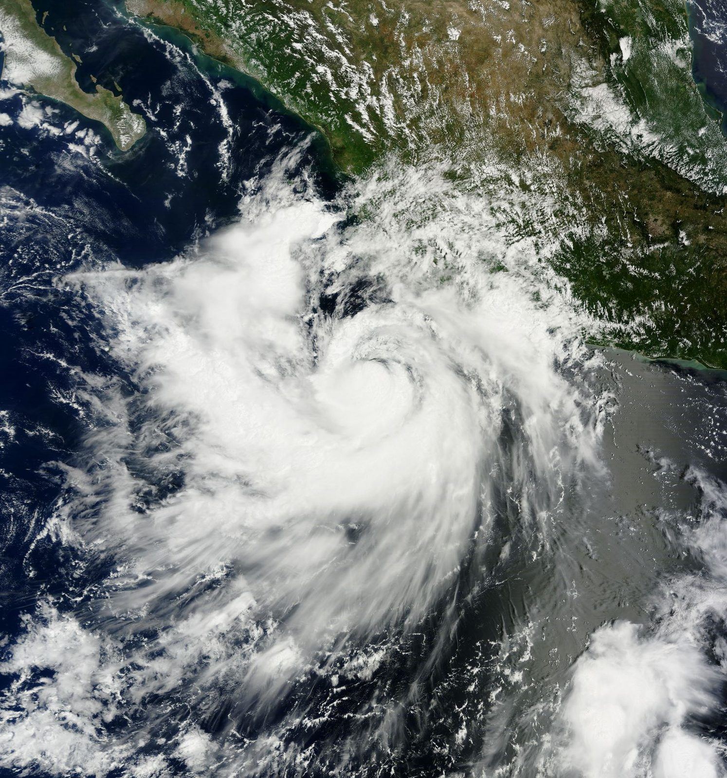
The 2026 Atlantic hurricane season has its first hurricane, and it is heading for the Gulf Coast. BBC Weather presenter Chris Fawkes reports that Hurricane Isaias is tracking toward the American Gulf Coast, where it could make landfall as early as Friday, carrying dangerous winds, a punishing storm surge and heavy rainfall.
The storm's arrival marks a late but potentially consequential start to a season that, until now, had produced tropical systems without a single hurricane. Forecasters are watching the Gulf's warm waters, which can feed a storm quickly in the final day before landfall. It is a pattern the Bureau has tracked across Gulf hurricane seasons (see our Hurricane Polo coverage).
What forecasters can say with confidence at this stage is the shape of the threat rather than its exact address. A Gulf Coast landfall on Friday would bring three compounding hazards: sustained winds strong enough to damage roofs and power lines, a storm surge that pushes seawater inland ahead of the center, and rainfall heavy enough to flood streets faster than drainage systems can clear them.
Gulf Coast communities know this sequence well, and emergency managers across the region typically begin staged preparations days ahead: fuel and water stockpiling, hospital and nursing-home evacuation planning, and the positioning of utility repair crews. The BBC report puts the emphasis where forecasters usually do at this range, on readiness rather than precision, because a shift of fifty miles in the track can decide which parishes flood and which merely lose power.
What no one can yet say is where exactly Isaias will come ashore, or how strong it will be when it does. Gulf hurricanes have a habit of changing character in the last twenty-four hours, sometimes weakening as they meet drier air, sometimes strengthening over deep warm water. Rainfall totals, the geography of the worst surge, and how long power outages might last all remain open questions until the storm commits to a final track.
A Gulf Coast hurricane is never only a weather story. The coastline from Texas to Florida holds the densest concentration of refining and petrochemical capacity in the United States, and even a glancing blow can idle refineries, close ports and ripple into gasoline prices within days. Insurers, still repricing Gulf risk after a bruising run of seasons, will be watching loss estimates before the water recedes, a dynamic the Bureau examined in its coverage of how a changing climate is reshaping ocean-driven extremes.
There is also the calendar. A first hurricane arriving in October, rather than August, lands on a public that has spent months hearing that the season was quiet. Preparedness research consistently finds that late first storms catch households under-supplied, a complacency tax paid in flooded cars and dark refrigerators.
Timing shapes behavior. By October, coastal residents have lived through months of tropical outlooks that came to nothing, and the psychological discount on the next warning is real. Emergency managers call it warning fatigue, and it is most dangerous precisely when the season's first real threat arrives late. The forecast may be accurate; the audience is tired of listening.
The Gulf of Mexico in early October remains bathtub-warm, and warm water is fuel. Storms crossing it can intensify right up to the coastline, which is why forecasters stress preparation for a storm one category stronger than the current advisory. It is the same late-season intensification pattern behind some of the costliest Gulf landfalls on record, and the reason flood-focused reporting on extreme rainfall keeps returning to the same lesson: water, not wind, does most of the killing.
There is a final wrinkle worth naming: the Gulf's offshore energy infrastructure itself. Platforms and pipelines are built to ride out storms, but a direct hit can shut in production for days, which is why a hurricane landfall and an energy crunch can share the same news cycle without any coordination between them. When they do, the price effects stack, and the storm stops being only a weather story.
Beyond the immediate coastline, the storm's second-order effects will show up in prices and portfolios. A multi-day refinery outage in the Houston-Port Arthur corridor can lift wholesale gasoline prices across the American South and Midwest within a week, and diesel markets, already tight, feel Gulf disruptions fastest because so much American trucking fuel is refined there. Ports from Corpus Christi to New Orleans may close to vessel traffic, delaying container and bulk shipments and adding a weather surcharge to supply chains still normalizing.
Insurers face the slower reckoning. Each Gulf landfall feeds the models that set next year's premiums, and a costly Isaias would accelerate the retreat of private coverage from the riskiest zip codes, pushing more homeowners toward state-backed insurers of last resort.
The next forty-eight hours are about the track. If Isaias holds its course, evacuation orders for low-lying parishes and counties will follow, and the Friday landfall window will narrow to a stretch of coastline. Then comes the weekend accounting: surge heights, rainfall totals, outage maps. And behind Isaias, the season is not over; October has produced some of the Atlantic's most destructive late storms, and forecasters will be watching the next wave off Africa before this one has even cleared. Insurers and emergency agencies will also be running the numbers that decide next year's premiums and budgets: a storm that stays offshore is a footnote, while one that floods a metro area becomes a line item in state finances for a decade.
The Western framing, visible in American coverage, treats Isaias as a test of preparedness systems: forecast accuracy, evacuation timing, grid hardening and the speed of federal disaster response. Markets read the same storm as a supply shock in waiting, pricing gasoline futures and refinery margins on the track forecast. The political lens is never far behind, since storm response has become one of the most legible measures of governing competence in coastal states.
Underneath sits a harder conversation about retreat and rebuilding. Every Gulf landfall reopens the question of whether federal flood insurance and disaster aid are subsidizing reconstruction in places the water will visit again, a debate that grows louder with each season while the building continues.
The Eastern lens has less direct stake in a Gulf landfall and reads the storm mainly through energy and shipping. A Gulf hurricane that idles American refineries tightens global product markets, diesel and jet fuel most of all, and shifts trade flows toward other refining centers. State-linked commentary tends to frame such disruptions as evidence of the fragility of concentrated Western infrastructure rather than as a shared climate emergency.
There is also a strategic reading: with global energy markets already taut, even a brief Gulf outage hands leverage to every producer outside the storm's path. The storm becomes a data point in a longer argument about who controls the world's spare refining capacity.
The Global South lens notices the asymmetry first. When a hurricane threatens the Gulf Coast, satellites, reconnaissance aircraft and wall-to-wall coverage mobilize; when comparable storms strike the Bay of Bengal or the Mozambican coast, the world's attention is thinner and the recovery money slower. The physics is the same, the protection is not.
For the South, the sharper question is what the storm does to prices. Gulf refinery outages lift the cost of diesel and cooking fuel far beyond American shores, and for import-dependent economies already squeezed by the energy crunch, a hurricane season in the Gulf is a second tax levied by someone else's weather.
BBC Weather reports that Isaias could make landfall on the Gulf Coast as early as Friday. The exact timing depends on the storm's forward speed over the next 48 hours, and forecasters will narrow the window as reconnaissance data comes in. Residents in the watch area should complete preparations by Thursday evening rather than waiting for a precise landfall hour.
A storm surge is seawater pushed inland by a hurricane's winds ahead of its center, and it is historically the deadliest part of a landfall. Just a few feet of fast-moving water can destroy buildings, wash out roads and trap residents who stayed behind. Surge heights depend on the storm's strength, size and angle of approach, which is why evacuation zones are drawn around water, not wind.
The Gulf Coast holds the largest concentration of oil refineries in the United States, turning crude into the gasoline and diesel the country runs on. When a hurricane forces refineries to shut down and ports to close, fuel supply tightens and wholesale prices rise within days. The effect is usually temporary, but a long outage can lift prices across the South and Midwest.
It is late but not unprecedented. Atlantic seasons vary widely, and some years produce their first hurricane well into autumn. The risk of a late first storm is behavioral: months of quiet outlooks breed complacency, so households are less prepared than they would be in August. Forecasters warn that October storms can still intensify rapidly over the Gulf's warm water.
