Hours after the first reports spoke of two injured, Xinhua put the toll from the magnitude 7.0 Nagqu quake at 16 killed and 32 injured, with at least 339 homes collapsed at nearly 5,000 metres of altitude.
Published 22 October 2026 · 22:16 GMT
Hours after the first reports spoke of two injured, Xinhua put the toll from the magnitude 7.0 Nagqu quake at 16 killed and 32 injured, with at least 339 homes collapsed at nearly 5,000 metres of altitude. A magnitude 7.0 earthquake struck Maru township in Baqen County, Nagqu City, northern Tibet, at 10:33 pm local time on Thursday, October 22, 2026 — the strongest quake to hit China since January 2024.
A magnitude 7.0 earthquake struck Maru township in Baqen County, Nagqu, northern Tibet, at 10:33 pm local time (14:33 GMT) on October 22, 2026; Xinhua, citing Nagqu City's emergency management bureau, reports 16 dead and 32 injured, and the Nagqu media office reports at least 339 homes collapsed.
On the rupture's depth — China's CENC measures 10 km, the USGS 18 km — and on whether the casualty figures have stabilized, given how fast the first reports were revised upward overnight.
The final casualty count, how many people are missing, the state of mountain access roads after rockfalls, the full housing-damage inventory, or how displaced families will be sheltered as the plateau winter sets in.
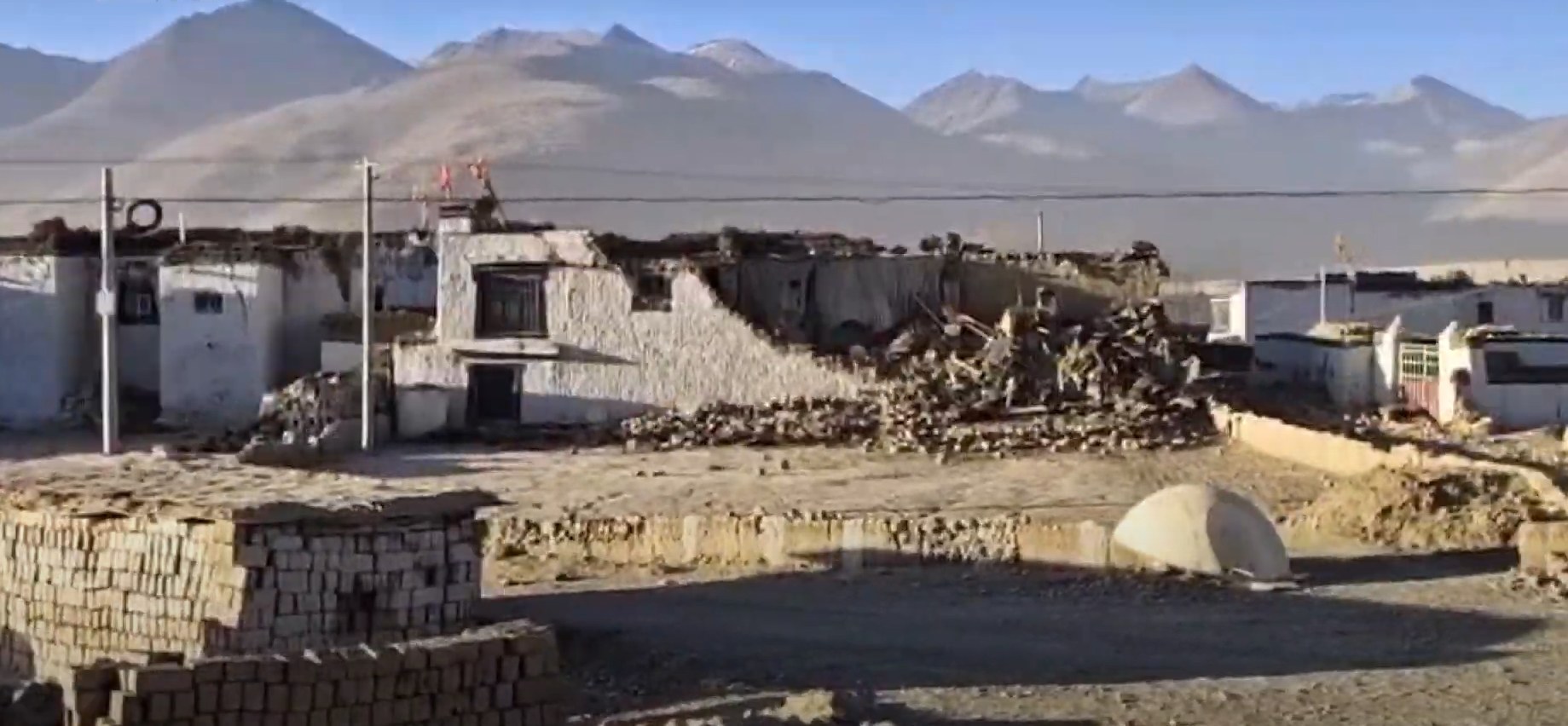
A magnitude 7.0 earthquake struck Baqen County in Nagqu City, in China's northern Tibet region, at 10:33 pm local time on Thursday, October 22, 2026 — and the human cost has climbed sharply since the first reports. Xinhua, citing Nagqu City's emergency management bureau, now reports 16 people killed and 32 injured (11 serious, 21 minor). Hours earlier, the first dispatches spoke of only two injured villagers near the epicentre; that overnight revision turns what briefly looked like a near-miss into the deadliest Chinese earthquake in nearly three years. Magna Bureau's initial wire report, published within hours of the shock, carried those first, fragmentary casualty figures.
The scale of destruction is coming into focus. The Nagqu media office, citing city government officials, says at least 339 homes collapsed in the tremor. State media footage showed residents leaving their houses for open ground and spending the night in cars parked along the streets. Beijing activated a Level-II earthquake disaster emergency response, and local fire and rescue teams were mobilized toward the high-altitude county through the night.
Seismologists place the epicentre in a mountainous area about 190 kilometres east-northeast of Nagqu and roughly 390 kilometres northeast of the regional capital Lhasa, in terrain averaging 4,864 metres above sea level. The quake is the strongest to strike China since January 2024.
Magnitude and time. The shock measured 7.0 — confirmed independently by the China Earthquake Networks Center and the US Geological Survey, which grades it a moment magnitude 7.0. It struck at 10:33 pm Beijing time (14:33 GMT) on October 22, 2026; the USGS timestamps the rupture at 14:33:40 GMT.
Epicentre. Maru township, Baqen County, Nagqu, in northern Tibet. The USGS places it 191 kilometres east-northeast of Nagqu; Maru's deputy head, Lhawang Dagpo, told Xinhua the quake was clearly felt at the township office, whose walls cracked. The average elevation within five kilometres of the epicentre is about 4,864 metres (15,960 feet).
Depth. China's CENC puts the rupture at 10 kilometres; the USGS estimates 18 kilometres. Both describe a shallow quake — the kind that does the most surface damage — and both figures are stated here because the two agencies' honest disagreement is itself a fact worth recording.
Casualties and damage. Sixteen dead and 32 injured (11 serious, 21 minor), reported by Xinhua via Nagqu City's emergency management bureau and local medics. At least 339 homes collapsed, per the Nagqu media office citing city government officials. State media video showed residents sheltering outside or in their cars.
Response and aftershocks. A Level-II earthquake disaster emergency response was activated, and local fire and rescue teams were dispatched to the region. Aftershocks of around magnitude 3 and 4 have been recorded nearby, CENC data showed. This is the strongest earthquake to hit China since January 2024 — and the Bureau's China country profile tracks how the plateau's fault systems have shaped its disaster history.
The central unknown is whether 16 dead is final. The leap from two injured to 16 dead within hours measures how incomplete the early picture was: scattered villages near the epicentre, at nearly 5,000 metres, may not yet have been reached, and the toll will move again as they are.
No detailed assessment of the mountain access corridors has been published. In Himalayan earthquakes, rockfalls and landslides are the classic second killer — they cut roads and isolate villages. Whether the routes into Maru township and the surrounding hamlets are passable is not yet on the public record.
There is no published figure for the missing — as distinct from the confirmed dead — and no inventory yet of livestock losses, which matter enormously in a herding economy heading into winter. The 339 collapsed homes is a floor, not a ceiling: what the Nagqu media office could confirm in the first hours, not a completed survey. How hundreds of displaced families will be housed as temperatures fall — in tents, heated shelters, or with relatives — will define the emergency's second phase.
Altitude is the defining feature of this emergency. At 4,864 metres, rescue crews work with roughly half the oxygen available at sea level: machinery underperforms, helicopters face thin-air limits, and the injured deteriorate faster. Every hour of delay at that elevation costs more than it would anywhere else in China.
Winter is the second clock. On the Tibetan plateau, late-October nights already bite hard, and collapsed homes mean exposure. The window for getting hundreds of displaced people under heated shelter is measured in weeks, not months — which is why the Level-II activation matters: it unlocks national-level resources rather than leaving the response to county authorities alone.
The quake is also a credibility test for Beijing's disaster apparatus on the roof of the world. The speed and candor of the toll revision — from two injured to 16 dead in a single night — will be read internationally as a transparency signal. China has invested heavily in its earthquake response system since the 2008 Sichuan disaster; Nagqu is where that investment must now perform.
Read through the Bureau's five-dimensional lens, the most important number in this story is not 16 but the distance between 2 and 16. Early casualty figures in a high-altitude disaster are not wrong so much as radically incomplete: they reflect only the places the information system has reached. The information chain runs from village to township to county to city bureau to Xinhua to the world wires, and every link costs hours on mountain passes at 4,800 metres. A toll that multiplies overnight is not a contradiction — it is the system working, and the candor of the revision is itself data. The Bureau's columnists have tracked this pattern across disasters: the first number measures access, not truth.
The depth discrepancy — 10 kilometres from CENC, 18 from the USGS — deserves the opposite reading: a small, honest window into how measurement works. Two serious agencies, two models, two answers, both published without embarrassment. Either depth describes a shallow, destructive rupture; neither changes the rescue math.
Geopolitically, a quake in Tibet gets the full world-wires treatment partly because of the plateau's weight — strategic, symbolic, hydrological. The attention brings scrutiny, and scrutiny brings resources. The test now is whether the mobilization in the state-media footage converts into heated shelter before the plateau winter closes the window.
The second-order story begins where the rescue ends. Rebuilding 339 or more homes at 4,864 metres, before winter and at thin-air logistics costs, is an engineering and fiscal undertaking of a different order than lowland reconstruction: materials must be hauled up mountain roads, the construction season is brutally short, and every delay compounds into a winter of displacement.
The quake will reopen the seismic-retrofitting question for the plateau's villages. Traditional Tibetan construction — thick walls of rammed earth and stone — performs poorly in strong shaking compared with the engineered frames of the cities, yet it is what the high villages are built from. Whether the reconstruction program mandates quake-resistant standards for rural housing, and who pays for the difference, will shape the plateau's vulnerability for a generation.
The immediate future is a race against access. Rescue teams pushing into the villages nearest the epicentre will determine whether the toll stabilizes at 16 or climbs — and their first situation reports, via the Nagqu authorities and Xinhua, will be the next hard data points. Follow the Bureau's rolling coverage as those revisions land.
The aftershock watch continues: the magnitude 3–4 sequence is typical after a 7.0 rupture, but on fractured high-altitude slopes, even moderate aftershocks can trigger the landslides that do the secondary killing.
Beyond the rescue window, expect the machinery of relief — tent settlements, heating supplies, altitude-adapted triage — and the first consolidated official briefings. The 48-hour mark is also when the missing-persons question sharpens: families unheard from, in villages unreached. That is the number to watch next.
The Western lens: instruments first, narrative later Western coverage, led by the AFP and Reuters wires, reads the quake the way it reads every quake: instruments first, narrative later. The USGS's independent depth estimate — 18 kilometres against CENC's 10 — gets equal billing, a quiet insistence that verification does not stop at borders. The framing is comparative: strongest in China since January 2024, with the 2010 Yushu earthquake in neighbouring Qinghai — at least 2,698 dead — as the instinctive scale anchor.
The Eastern lens: mobilization and mechanism Chinese state media, through Xinhua and the CENC, frame the story as a mobilization narrative: precise epicentre coordinates, township-level detail — the cracked walls of the Maru office, the words of deputy head Lhawang Dagpo — and the machinery of the state visibly engaging, from the Level-II activation to the fire brigades on the road. Singapore's CNA keeps the same factual spine while adding the historical memory Western wires reach for less: Yushu 2010, and the pattern of strong plateau quakes arriving in clusters.
The Southern lens: the Himalayan neighbourhood For the Global South, this is a neighbourhood story. Al Jazeera in Doha and The Hindu in Chennai carried the live file through the night — the two newsrooms that stayed closest to the toll as it moved — because the Himalayan arc is shared risk: Nepal, Bhutan, northern India and Tibet sit on the same fault system, and the memory of Nepal's 2015 Gorkha earthquake still shapes how the region reads every tremor. The Southern framing is material rather than instrumental: homes of mud and stone at 4,800 metres, herders days from a hospital, a winter that does not negotiate.
A magnitude 7.0 earthquake struck Maru township in Baqen County, Nagqu City, northern Tibet, at 10:33 pm local time. Xinhua, citing Nagqu City's emergency management bureau, reports 16 people killed and 32 injured, with at least 339 homes collapsed. The epicentre lay about 190 km east-northeast of Nagqu at nearly 5,000 metres of altitude, making it the strongest quake to hit China since January 2024.
The first dispatches spoke of only two injured villagers near the epicentre; hours later the toll stood at 16 dead and 32 injured. Early figures in a high-altitude disaster reflect only the places information has reached. As rescue teams pushed into remote villages at nearly 5,000 metres, the fuller picture emerged — a normal, if sobering, pattern in mountain earthquakes.
China's CENC measures the rupture at 10 km deep; the USGS estimates 18 km. Both describe a shallow quake, and shallow quakes do the most surface damage. The honest disagreement between two serious agencies is itself informative — it shows measurement in progress, not failure — and neither figure changes the rescue math on the ground.
In Maru township, Baqen County, Nagqu, in northern Tibet — a mountainous, sparsely populated high-altitude county. The USGS places it about 191 km east-northeast of Nagqu and 390 km northeast of Lhasa, with an average elevation of 4,864 metres within five kilometres. The township office itself sustained cracked walls, according to Xinhua.
China operates a four-tier earthquake emergency system, with Level I the highest. Level II — the second-highest tier — is activated for major disasters and unlocks national-level resources: central coordination, military and paramilitary rescue units, and priority funding. Its activation for Nagqu signals that Beijing treats this as a national, not merely local, emergency.
