A powerful magnitude 7.0 earthquake struck Baqen County in northern Tibet late on Thursday, injuring at least two people and cracking homes near the epicentre, state media reported. Rescue teams are converging on the high-altitude region as Beijing activated a Level II emergency response — the strongest quake to hit China since January 2024.
Published 22 October 2026 · 20:28 GMT
A powerful magnitude 7.0 earthquake struck Baqen County in northern Tibet late on Thursday, injuring at least two people and cracking homes near the epicentre, state media reported. Rescue teams are converging on the high-altitude region as Beijing activated a Level II emergency response — the strongest quake to hit China since January 2024. A magnitude 7.0 earthquake struck Baqen County in Nagqu City, northern Tibet, at 10:33 pm local time on Thursday, October 22, 2026 — the strongest quake to hit China since January 2024.
A magnitude 7.0 earthquake struck Baqen County in Nagqu, northern Tibet, on October 22, 2026 at 10:33 pm local time; state media reported at least two people injured and houses cracked near the epicentre, and Beijing activated a Level II emergency response.
On the exact depth of the rupture — CENC measures 10 km, the USGS 18 km — and on what the final casualty count will be once rescue teams reach the most remote high-altitude villages.
The full scale of building damage across the scattered villages near the epicentre, whether mountain road corridors are cut by rockfalls, or whether the casualty count will rise after daylight damage assessments.
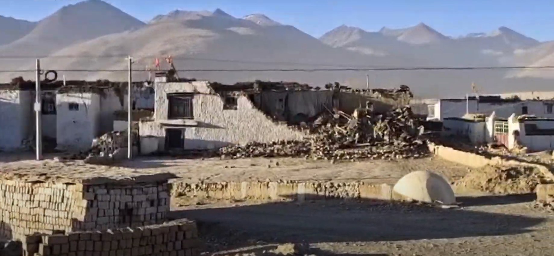
The ground moved at 10:33 on Thursday night, and on the roof of the world that means something different than anywhere else. A magnitude 7.0 earthquake ripped through Baqen County in Nagqu, northern Tibet — high, cold, and far from anywhere — at a depth China's monitors put at 10 kilometres. The China Earthquake Networks Center fixed the epicentre at 32.40 degrees north, 93.79 east; the US Geological Survey, measuring independently from the other side of the planet, agreed on the magnitude and placed the depth a little deeper, at 18 kilometres.
Within hours, the state broadcaster reported the first human cost: at least two people injured in a village near the epicentre, houses cracked in the villages closest to the shaking. Fire and rescue teams mobilised and headed for the high plateau while the China Earthquake Administration activated a Level II emergency response — the machinery of a state that has practised for exactly this. It is the strongest earthquake to strike China since January 2024.
Start with what the instruments agree on, because that is the firm ground here. The quake struck at 10:33 pm local time on Thursday, October 22 — 1433 GMT — in Baqen County, part of Nagqu City in the Tibet Autonomous Region. The epicentre sits in a sparsely populated, high-altitude pocket of northern Tibet, around 190 kilometres east-northeast of Nagqu itself and roughly 400 kilometres from Lhasa; the average elevation within five kilometres of the epicentre is about 4,864 metres.
The magnitude is uncontested at 7.0 — CENC, the USGS, and Germany's GFZ all converge there. On depth the instruments politely disagree: 10 kilometres per CENC and Xinhua, 18 per the USGS. What the early accounts describe: the shaking was clearly felt across the local area; officially run media showed residents leaving their homes for shelter outside or in parked cars; at least two people were injured and houses near the epicentre show cracks, per the state broadcaster via Reuters. The response is already in motion: a Level II emergency response, rescue teams converging, and a string of aftershocks around magnitude 3 and 4 recorded in the surrounding region.
Everything else is still coming into focus, and honesty requires saying so. The final casualty count is unknown — the quake struck at night, in remote terrain, at an altitude where even breathing is work, and the first reports always undercount. The full extent of building damage across the scattered villages around the epicentre — Lengda, Puqin, Gaijia Ka, the townships of Gangqie and Maru within twenty kilometres — has not been surveyed; daylight will change the picture.
Whether roads and the National Highway 317 corridor are cut by rockfalls is unconfirmed. And the depth discrepancy between CENC and the USGS, small as it sounds, matters for modelling how the shaking propagated — the final parameters will be revised in the coming days.
Two injured is a merciful number, and it would be a mistake to read it as a small story. The Tibetan Plateau is where the Indian and Eurasian tectonic plates are still colliding — the engine that built the Himalayas and one of the most seismically violent places on Earth. A 7.0 here is a systems test: of the rail and road corridors Beijing has spent two decades threading across the plateau, of the emergency drills Baqen County ran as recently as May and September, of a monitoring network whose speed — parameters within the hour — now rivals anyone's.
It is also a regional story wearing a local face. The same fault systems threaten Nepal, Bhutan, and northern India — a risk geography the Magna Factbook tracks country by country — and the memory of the January 2025 Tingri quake, which killed at least 126 people, is barely twenty-one months old. When the ground moves at 4,864 metres, ministries from Beijing to New Delhi pay attention.
That is the question this quake quietly poses, and it is worth sitting with. Tibet is not an easy place to report from — as another Tibet story this week showed, the region's news often reaches the world through detours. The first credible casualty figure came not from an international crew but from the state broadcaster, relayed by Reuters. The Bureau's rule in such moments is simple: triangulate or stay silent.
Here triangulation was possible — CENC, USGS, and GFZ converged on magnitude; AFP, AP, and Reuters converged on the response; the depth discrepancy was reported as a discrepancy, not smoothed over. The deeper 5D read: Beijing's emergency apparatus has clearly absorbed the Tingri lesson — parameters published within the hour, Level II activated overnight, rescue columns moving before dawn. Speed is a policy choice, and it is one China now makes consistently. The plateau, meanwhile, keeps its own counsel: a 7.0 with two injured is luck married to preparation, and luck is not a strategy. The next one will come — the only variable is whether the drills outrun it.
The first knock-on effects are already in motion. Aftershocks in the magnitude 3–4 range will rattle already-cracked houses for days, and each one complicates the damage survey. Winter is closing in on the plateau — shelter is not an abstraction at nearly 5,000 metres in late October. Supply lines into Baqen run through mountain corridors where rockfalls, already reported, can sever a valley with a single slope failure.
Then the slower ledger: reconstruction costs in one of China's most logistically punishing terrains — at a moment when Beijing is already weighing stimulus for a slowing economy — the strain on local medical capacity, and the data dividend. Every second of this rupture feeds the seismic models that will forecast the next one.
Daylight is the next instrument. The damage surveys now under way will revise the casualty and housing numbers — upward is the historical pattern, and the Bureau will update rather than speculate. Watch the aftershock sequence: a tapering curve means the fault is settling; a fresh 5-plus means the response escalates.
Watch whether the Level II response steps down to relief-and-reconstruction or holds at emergency footing. And watch the final parameters from CENC and the USGS — when the two converge on depth, the modelling of this rupture is done. The plateau has spoken once this week; seismology says it rarely speaks only once.
The Western lens: seismographs first, questions second Western coverage, led by Reuters, AP, and AFP, reads the quake the way it reads every quake: instruments first, narrative later. The USGS's independent depth estimate gets equal billing with CENC's — a quiet insistence that verification does not stop at borders. The framing is comparative and forward-looking: strongest in China since January 2024, aftershock sequences to watch, and the inevitable contrast with the 2010 Yushu disaster, when a 7.1 killed at least 2,698 people.
The Eastern lens: the state machine switches on Chinese state media tells a story of a machine that was ready. Xinhua's dispatch is brisk: magnitude, coordinates, depth, Level II response activated. The state broadcaster shows orderly residents sheltering outside, rescue teams converging, officials in motion — and the subtext is preparedness.
The Global South lens: the Himalayas don't respect borders From the Global South, this is a neighbourhood story. India's PTI, The Hindu, and The Tribune report it with the attentiveness of countries that share the same restless geology — the plateau's tremors are the subcontinent's tremors. South Africa's TimesLIVE, carrying Reuters, frames it for an African readership watching another developing-world disaster response unfold in real time.
The epicentre was in Baqen County, part of Nagqu City in the northern Tibet Autonomous Region, at coordinates 32.40°N, 93.79°E. It sits in a sparsely populated, high-altitude pocket — about 190 km east-northeast of Nagqu and roughly 400 km from Lhasa — with terrain averaging 4,864 metres above sea level.
State media reported at least two people injured in a village near the epicentre, with houses in the closest villages showing cracks. That figure comes from the first overnight reports; the final count is not yet known, as rescue teams were still reaching remote high-altitude settlements when the reports were filed.
The Tibetan Plateau sits directly over the collision zone of the Indian and Eurasian tectonic plates — the same slow-motion crash that built the Himalayas. The ongoing pressure generates immense geological stress, making the plateau one of the most seismically active regions on Earth, with major quakes a recurring fact of life.
It is one of the top tiers of China's four-level earthquake emergency system, activated by the China Earthquake Administration for major quakes. It triggers the rapid deployment of national rescue teams, relief supplies, and medical support to the affected region, with central authorities coordinating alongside local officials.
Not directly — the two struck different fault systems about 21 months apart, Tingri in the Shigatse region near Nepal and this one in Nagqu in northern Tibet. But they share the same tectonic engine: the Indian-Eurasian plate collision. The Tingri quake killed at least 126 people and reshaped Beijing's preparedness posture.
