Packing 150 mph winds and a 932-millibar core, Simon sits just 85 miles off Manzanillo after strengthening with alarming speed. Mexico’s west-central coast is bracing for a major-hurricane landfall, life-threatening rain, and destructive surf.
Published 11 October 2026 · 00:06 GMT
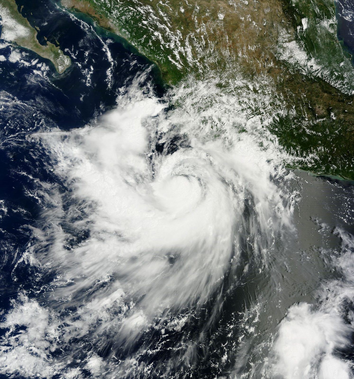
Hurricane Simon is now a monster by every measure that matters. The US National Hurricane Center’s 6:00 PM CST advisory on Saturday, October 10, placed the Category 4 storm about 85 miles south-southwest of Manzanillo and 180 miles south-southeast of Cabo Corrientes, packing maximum sustained winds of 150 mph (240 km/h) around a 932-millibar core. It was crawling north at just 3 mph: a slow, coiled threat aimed at Mexico’s west-central coast.
The speed of the transformation is what has forecasters alarmed. On Friday morning Simon was a 90 mph hurricane, 220 miles south of Manzanillo. By Saturday noon it was a 145 mph storm; by evening, 150 mph and Category 4. Roughly 33 hours, 60 mph of intensification — the kind of rapid strengthening that leaves coastal populations almost no time to adjust.
Along the coastline, the preparations told the story before the wind arrived. In Puerto Vallarta, businesses boarded windows and stacked sandbags; hotels were instructed to make sure shelters were ready. Jalisco suspended classes on Friday and Monday in 22 coastal municipalities and began moving people out of at-risk areas. Manzanillo, Mexico’s largest Pacific port, sat squarely inside the threatened zone.
Advisory 14A, issued 6:00 PM CST Saturday by forecaster Cangialosi: 17.9°N, 104.8°W — 85 miles south-southwest of Manzanillo, 180 miles south-southeast of Cabo Corrientes. Maximum sustained winds 150 mph, minimum central pressure 932 millibars, Category 4. Hurricane-force winds extend 25 miles from the center; tropical-storm-force winds reach 90 miles. Movement: north at 3 mph, expected to continue north over the next day or two.
A hurricane warning is in effect from Punta San Telmo to El Roblito, including Las Islas Marías; a tropical storm watch runs east of Punta San Telmo to Lázaro Cárdenas. Hurricane conditions are expected in the southern warning area early Sunday, tropical-storm conditions possible as soon as Saturday night. Dangerous storm surge is forecast near and east of wherever the center comes ashore, with large destructive waves — plus life-threatening surf and rip currents along southwestern and west-central Mexico.
The rainfall forecast is the document’s grimmest paragraph: 10 to 20 inches across southwestern Mexico through Sunday, isolated maxima of 30 inches in Michoacán, Colima and Jalisco. “This rainfall will produce life-threatening flooding and mudslides, especially in areas of steep terrain.” And one crucial negative fact: as of 6:00 PM, landfall had not occurred. Everything ahead is forecast, not history.
The official forecast says “near or just inland over west-central Mexico on Sunday,” moving farther inland Monday — but a track hugging the coastline without fully coming ashore remains possible, and the difference between a direct hit on the Colima coast and a 50-mile offshore parallel track is the difference between catastrophe and a bad storm. The exact hour of closest approach is likewise unknowable; hurricane wobbles of a few dozen miles are routine.
A second unknown is the storm’s peak. Market analysts at artemis.bm float a possible brief Category 5 peak — around 155 mph — followed by weakening to roughly 135–140 mph at landfall. That is a forecast interpretation from the catastrophe-bond world, not the Hurricane Center’s official call. Whether Simon finds a final overnight burst or begins the eyewall-replacement weakening that often precedes landfall will only be known in the morning advisories.
The third unknown is damage, and it is total: with no landfall yet, there are no confirmed damage reports or casualty figures. Rainfall totals, surge heights, the mudslide count — all of it is still potential energy. By Monday, events will have rewritten this section.
Rapid intensification is the phenomenon that keeps forecasters up at night, and Simon is a textbook case. AccuWeather’s Dan Pydynowski: “Simon has strengthened incredibly quickly, and that’s what makes storms like this so dangerous.” A storm gaining 60 mph in a day and a half compresses the entire decision cycle — evacuation, sheltering, port closure, hospital readiness — into hours. Populations that planned for a Category 1 on Friday face a Category 4 on Saturday night.
Then the geography of the threat. Mexico’s Pacific coast from Guerrero to Jalisco is steep country: the Sierra Madre drops fast to the sea, and river valleys turn 20 inches of rain into walls of water and mud. The mudslide warning is not boilerplate; it is the documented killer in these storms. A 3 mph forward speed means the rain bands sit over the same watersheds for hours — and the flood math turns ugly.
The economic exposure is concentrated too. Manzanillo is Mexico’s largest Pacific container port; a warning there means suspended operations and a cargo queue that does not politely wait — in October, pre-holiday inventory days for North American supply chains. Puerto Vallarta is a flagship tourist destination. Inland, the farm belts of Colima and Michoacán sit under the heaviest forecast rain. For a past Pacific storm’s aftermath, see Hurricane Polo’s Pacific rampage.
Simon belongs to a class of eastern Pacific hurricanes worrying scientists for a decade: the rapid intensifiers. The ingredients were all present — very warm sea-surface temperatures off Mexico’s Pacific coast in mid-October, low vertical wind shear, a moist atmospheric column. What turned them into a Category 4 in 33 hours was the feedback loop: a tightening core drops central pressure, pulling in more warm moist air, fueling deeper convection, dropping pressure further. Once engaged, only land interaction or an eyewall replacement cycle — the storm choking on its own intensity — typically stops it.
The 3 mph forward speed deserves its own analysis, because slow storms are flood storms. A fast hurricane spreads rain along its track; a slow one parks its rain bands over the same river basins for 12, 18, 24 hours. Mexico’s Pacific slope concentrates that water downhill with brutal efficiency. Wind will damage roofs near the coast; water will kill people tens of miles inland, in valleys that never see the eyewall. Emergency managers know this — it is why the rainfall paragraph, not the wind paragraph, is the longest in the advisory.
There is seasonal context too. Mid-October is late in the eastern Pacific season but not anomalously so. What is notable is Simon’s company: Tropical Storm Rachel was simultaneously active off Baja California — a different system, not to be confused, but a reminder the basin was broadly primed. When the whole ocean is warm, single-storm narratives understate the systemic risk.
The first ripple is logistical. Manzanillo handles the largest container volumes of any Mexican Pacific port; a hurricane warning means suspended operations, vessels ordered to sea, and a cargo queue that does not politely wait. Even a near-miss sparing the cranes costs days of throughput — and the port’s reopening timeline will be one of the first economic indicators out of the storm.
The second ripple is agricultural. Colima and Michoacán sit under the 30-inch isolated maxima: lime groves, avocado orchards, sugar cane — crops that do not survive prolonged inundation. Mexico’s lime and avocado exports are globally significant; a severe hit would show up in North American produce prices within weeks, the kind of second-order inflation that never makes the storm’s Wikipedia page.
The third ripple is financial. The catastrophe-bond market was already modeling Simon before landfall — artemis.bm’s analysis is the market pricing risk in real time. Each rapid intensifier that beats the models reprices Pacific hurricane risk upward, which reprices insurance, which reprices coastal development. And the fourth ripple is infrastructural: Puerto Vallarta’s grid, roads and water systems face their hardest test in years, in a town whose economy cannot afford a long outage.
The timeline from here is measured in advisories. Tropical-storm conditions could reach the coast as soon as Saturday night; hurricane conditions are expected in the southern warning area early Sunday; the center’s closest approach or landfall falls on Sunday, October 11, with the storm moving farther inland and weakening Monday. The next full advisory was due 9:00 PM CST Saturday, with intermediates every few hours through landfall.
Watch the wobbles. Hurricane tracks jog dozens of miles in the final 24 hours, and each jog redraws the landfall map — a 30-mile eastward wobble at 3 mph is the difference between Manzanillo’s port taking the eyewall and watching it pass. Mexico’s National Meteorological Service track and the Hurricane Center’s cone should be read together, not as competitors.
And watch the rain gauges, not just the wind. By Monday morning the story will have two chapters: the coastal chapter, written in wind and surge, and the inland chapter, written in river levels across Michoacán, Colima and Jalisco. The second chapter is usually longer, deadlier, and less photographed. It is also the one the warnings were really about.
The Western framing is the forecaster’s framing: the Hurricane Center’s advisories as the authoritative text, the Saffir-Simpson categories as the shared language, preparedness as the civic duty. Simon becomes a physics problem with a human deadline — 932 millibars, 150 mph, 3 mph forward speed — and the story is whether checklists get completed before it arrives. Rapid intensification is the variable that breaks planning assumptions. The US lens also notes what’s absent: no American coastline in the cone, so no American politics in the storm.
The Eastern framing, carried by Al Jazeera, centers human geography over meteorology: the boarded shops of Puerto Vallarta, suspended school terms in 22 Jalisco municipalities, evacuations already underway. The storm becomes a test of state capacity in the Global South — whether warnings reach fishing villages as fast as resorts, whether shelters exist for the people the cameras don’t show. Hurricanes are democratic in their rain and aristocratic in their protection; who gets which is the real story. Past Gulf hurricanes show the pattern: Hurricane Isaias’ Gulf approach.
The Global South framing — Mexico’s own — is operational: civil protection alerts, naval port closures, governors coordinating evacuations, the National Meteorological Service’s parallel advisories. Simon is the latest exam in a country that takes hurricanes seriously because it has paid for not doing so. The emphasis falls on the vulnerable geography international coverage underplays — the steep coastal municipalities of Michoacán and Guerrero, far from the Vallarta cameras, where 30 inches of rain on deforested slopes is the nightmare scenario. A previous storm’s aftermath ledger is here: Isaias’ aftermath: outages and recovery.
As of the National Hurricane Center’s 6:00 PM CST advisory on Saturday, October 10, Simon packed maximum sustained winds of 150 mph (240 km/h) with a minimum central pressure of 932 millibars — solidly Category 4 on the Saffir-Simpson scale of 1 to 5. Category 4 means catastrophic damage potential: winds that tear roofs off well-built homes and uproot most trees. It strengthened from 90 to 150 mph in about 33 hours.
The official forecast calls for the center to move near or just inland over west-central Mexico on Sunday, October 11 — possibly the Colima or Jalisco coast — then farther inland Monday. The hurricane warning runs from Punta San Telmo to El Roblito, plus Las Islas Marías, with a tropical storm watch east to Lázaro Cárdenas. As of Saturday evening, landfall had not happened, and a track staying just offshore remains possible.
Because of the terrain and the totals. The Hurricane Center forecasts 10 to 20 inches of rain across southwestern Mexico through Sunday, with isolated maxima of 30 inches in Michoacán, Colima and Jalisco. In its own words, that rain ‘will produce life-threatening flooding and mudslides, especially in areas of steep terrain’ — and Mexico’s Pacific slope is steep terrain. In Pacific hurricanes, water has historically killed far more people than wind.
The Hurricane Center’s blunt instruction: ‘Preparations to protect life and property should be rushed to completion in the hurricane warning area before conditions deteriorate later tonight.’ Jalisco suspended classes Friday and Monday in 22 coastal municipalities and began evacuating at-risk zones; Puerto Vallarta hotels were told to ready shelters; businesses boarded windows and stacked sandbags. The next full advisory was due at 9:00 PM CST Saturday.
